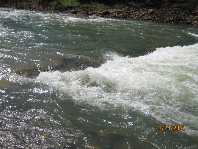
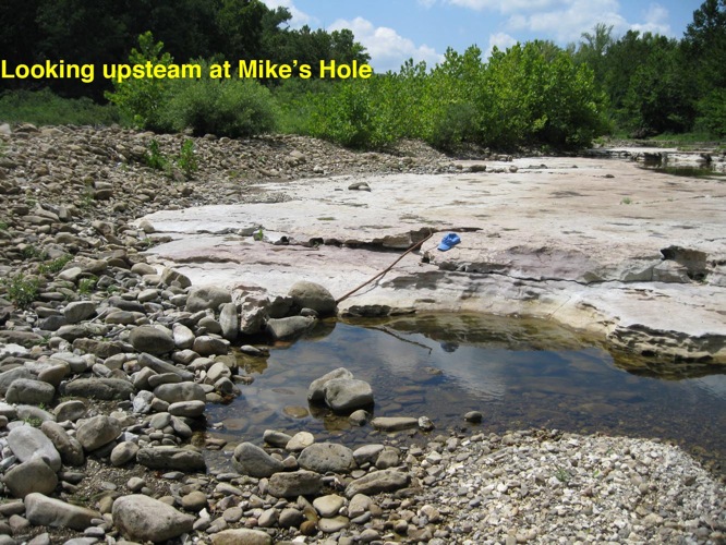
This ledge is just below Edgeman/Moore Creek, one and one half miles below the Boxley Bridge, and 400 to 500 yards ENE of Highways 21/43 Junction.
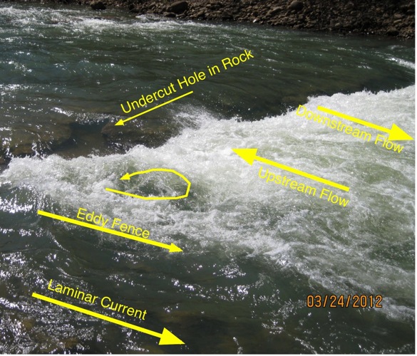
Marked to show direction of the various currents:
Between Boxley and Ponca, the Buffalo River at normal levels (around 300 cfs on Boxley gage) is a small, pool and drop whitewater stream with several long stretches of easy class 2 whitewater. Strainers, in the form of trees and root balls, are the most common hazard, although at high levels, as river begins to get out of it banks, waves and hydraulics/holes get much larger, and there are fewer eddies. At all levels, several small ledges make river wide waves.
Saturday, March 24, 2012 was a beautful day and all of the area rivers had been very high all week and were still higher than normal. The Boxley gage was 500 cfs 54 deg F, the feeder creeks were running hard, hence the Ponca gage had about 1000 cfs and only small air gap at the Ponca bridge. There was a lot of traffic putting in a Boxley that day, mostly in traditional open canoe, some whitewater canoe, ww kayaks, inflatables, rec kayak, and at least one SUP.
Not far below our put-in at Boxley Bridge, one of our group flipped his canoe, swam across a small ledge, and was caught in a hole near one end of the ledge. He was circulated in the hole for a minute or so, able to get a quick breath on each upstream ride, but unable to get himself out of the recirculation. Others in the group hit him with a rope and got him to shore fairly quick, but he was so exhausted that group took out at next access.
Here's the ledge as it looked in March:
This ledge is just below Edgeman/Moore Creek, one and one half miles below the Boxley Bridge, and 400 to 500 yards ENE of Highways 21/43 Junction.
Marked to show direction of the various currents:
It surprised us that this narrow hole could keep a full size man. It's maybe six feet long, narrow, and blocked on river right by a small, strong eddy whirl. On his upsteam ride, Mike was near the surface and could be seen going fast, straight upsteam, for a few feet, then down and out of sight until popping up again at the lower end of the hole's upstream current. He said he never hit bottom, side, or anything while recirculating.
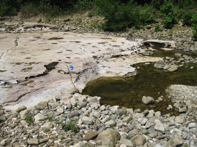
Neither the ledge and nor the hole just seemed big enough to hold and circulate a person of Mike's size, so with the river dry in July, I went back to take another look:
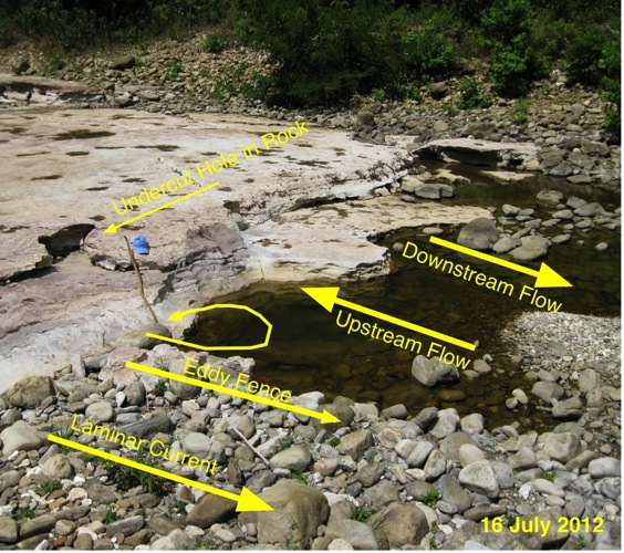
Same image marked to match the March photo.
The "undercut rock" at top edge of the ledge makes a clear reference in both set of photos.
The wooden walking stick is nearly 5 feet long.
Under the eddy fence/wall is actual bed rock wall, topped with river rock.
From downstream and a different angle, the bed rock that under lies the eddy fence is visible.
Here's the Video that shows the currents, and includes same "undercut rock" at top edge of the ledge.
This 50 foot wide ledge is about the mid point of a set of rapids roughly 500 feet long, with maybe 6 feet of drop from top to bottom. This section is nearly straight, and while this ledge runs 90 degrees across the river bed and current, the small ledge just up stream is 45 degree diagonal to bed and current. The whole area, from Moore Creek to bottom of the rapid is on a flat slab base, round river rock collects at certain places and actually makes a large island the full 500 foot length. The river is running left side of the island now, but everything is this area can change quickly, main channel can shift, rocks routinely move, and the whole loose rock island can be shifted in certain situations.
I estimate that the spot that held and recirculated Mike in March may have been 5 to 6 feet deep. The arrow marking "Upstream Flow" is about the path he rode, the small gravel deposit between the Up and Down arrows is consistent with a calm or neutral area between the two opposing flows. While most of this ledge steps, or benches, down, the area between Eddy Fence and Upstream Flow markers has a single, steep drop. There are steps on both sides of the steep drop that form a shallow "U" around the deep depression/bowl. The near side of the depression/bowl has an extension of the bedrock step that, along with a couple of large, loose rocks, make a physical wall for the bowl under the label "Eddy Fence".
After seeing the bedrock shelf extension that makes a true wall between Laminar Current and the whirl, I can see in the video, the Laminar Current breaking over into the eddy and enforcing/causing the whirl. Other secondary effects and references are also visible when comparing March and July images and video.
All this brings me to a some conclusions:
First, seeing the river bed nearly dry is a big help in understanding the hydraulic features we see in in whitewater.
Second, nature compounds the simple, stand alone features that are usually shown in books into more complex situations.
Third, there are lot more dangers in these flat slabs than I expected. I saw several holes a foot or two deep with sharp rock edges on top that could be a horrifying foot trap. Also there many small undercuts, sharp edges, and rock shapes that could really beat up a swimmer in fast current.
Return to Instruction Notes ...or... River Gages
correct date… 19 Sept 2012 A Bowie